home click highlighted hoovered text for more info, see help

Australia maritime + continental UNESCO world heritage sites

Heard island

Heard Island and McDonald Islands via Freemantle at Spit Bay
Discovered in the mid-19th century, the islands have been an Australian territory since 1947 and contain the country's only two active volcanoes. The summit of one, Mawson Peak, is higher than any mountain on the Australian mainland. The islands are currently uninhabited.

Lord Howe island

Lord Howe island via Port Macquarie Airport at 99 Boundary Street
The Lord Howe Island Group is an outstanding example of oceanic islands of volcanic origin containing a unique biota of plants and animals, as well as the world's most southerly true coral reef. It is an area of spectacular and scenic landscapes encapsulated within a small land area, and provides important breeding grounds for colonies of seabirds as well as significant natural habitat for the conservation of threatened species.

Macquarie island

Macquarie Island via Hobart at Macquarie Wharf
Macquarie Island has outstanding universal value for two reasons. First, it provides a unique opportunity to study, in detail, geological features and processes of oceanic crust formation and plate boundary dynamics, as it is only place on earth where rocks from the earth's mantle (6 kilometres below the ocean floor) are being actively exposed above sea level. These unique exposures include excellent examples of pillow basalts and other extrusive rocks. Second, its remote and windswept landscape of steep escarpments, lakes, and dramatic changes in vegetation provides an outstanding spectacle of wild, natural beauty complemented by vast congregations of wildlife including penguins and seals.

New South Wales state south [capital = Sydney]

Mungo National Park in Mungo on 3046 Turlee Leaghur Road
Willandra Lakes Region World Heritage Area is an ancient landscape formed by wind and water. The area includes a small section that is Mungo National Park, where Mungo Lady and Mungo Man were uncovered. Dating human habitation back to more than 40,000 years the discovery is believed to be the world's oldest site of ritual ceremony. Preserved in the arid environment are ancient fireplaces, calcified plants, stone tools, and animal bones.
Hyde Park Barracks in Sydney on Queens Square, Macquarie Street
As the principal male convict barracks in New South Wales it provided lodgings for convicts working in government employment around Sydney until its closure in mid-1848.
Opera House in Sydney at Bennelong Point
The Sydney Opera House constitutes a masterpiece of 20th century architecture. Its significance is based on its unparalleled design and construction; its exceptional engineering achievements and technological innovation and its position as a world-famous icon of architecture. It is a daring and visionary experiment that has had an enduring influence on the emergent architecture of the late 20th century.
Convict site & shipyard in Sydney on Cockatoo Island
Between 1839 and 1869, Cockatoo Island operated as a convict penal establishment, primarily as a place of secondary punishment for convicts who had re-offended in the colonies. Cockatoo Island was also the site of one of Australia's biggest shipyards, operating between 1857 and 1991. The first of its two dry docks was built by convicts. Listed on the National Heritage List, the island is significant for its demonstration of the characteristics of a long-running dockyard and shipbuilding complex, including evidence of key functions, structures and operational layout.
Old Government House in Parramatta at 1A Pitt Street
It is considered a property of national and international significance as an archaeological resource. It also serves to demonstrate how the British Empire expanded and Australian society has evolved since 1788.
Blue Mountains National Park in Katoomba at Echo Point Lookout, Echo Point Road
Renowned for the Three Sisters rock formation, the Blue Mountains National Park incorporates many other spectacular landmarks and offers opportunities for exploration and immersion into nature. Enjoy exhilarating walks, discover Aboriginal history, hike to tumbling waterfalls and enjoy picnics in parks with stunning, far-reaching vistas of ancient escarpments and forest-clad valleys.
Great North Road in Gunderman at Dharug National Park
In 1825 the NSW Government began work on an inland road to connect Sydney to the Hunter Valley, a distance of 264 kilometres. Up to 720 convicts worked on the Great North Road and built stonework including buttresses, culverts, bridges and 9-metre-high retaining walls.
Barrington Tops National Park in Nelson Bay at 12B Teramby Road
The World Heritage Area is a direct window into the past and the future, providing a link to the ancient pre-human world and a stunning and irreplaceable record of life on our planet. You can explore the rainforest on one of the park's many walking tracks, like the Honeysuckle Forest track, the Rocky Crossing walk or the Antarctic Beech Forest track.

New South Wales state central [capital = Sydney]

Mount Seaview Nature Reserve in Mount Seaview on Seaview Street
Mount Seaview Nature Reserve was created in February 1965. It covers an area of 1704ha. There is no public access to this reserve.
Werrikimbe National Park in Forbes River on Cockerawombeeba Road
Part of the Gondwana Rainforests of Australia World Heritage Area, it's a unique natural landscape with ancient rainforest, tall eucalypt forests, pristine rivers, cascading waterfalls, rugged escarpment and deep gullies.
Willi Willi National Park in Moparrabah on Hastings Forset Way
Willi Willi National Park forms an extensive mountain wilderness on a spectacular section of the Great Dividing Range. The park protects some of the best subtropical and warm temperate rainforests in Australia. The landscape is typically characterised by deeply dissected forest-lined valleys and lush groundcover.
New England National Park in Darkwood on Darkwood Road
Discover the ancient world sealed in Gondwana rainforest, wander through snow gum forests dotted with crimson rosellas, and see breathtaking views from the Great Escarpment on one of the many walking tracks. Walks range from an easy 200m stroll to multi-day hikes through remote wilderness.
Dorrigo National Park in Never Never on Rosewood Creek Track
Dorrigo National Park, part of the Gondwana Rainforests of Australia World Heritage Area offers stunning scenery that has been millions of years in the making. The park contains a range of forest types that protect an enormous variety of animals and birds, like red-necked pademelons, the vibrantly coloured wompoo fruit-dove and the spectacular regent bowerbird.
Mount Hyland Nature Reserve in Marengo at 142 Dome Road
Aboriginal people in the area have a strong connection to their traditional lands and maintain connection through conservation and resource management. Sites of high cultural significance are located along the traditional walking routes between Boyd River and high country around the village of Ebor
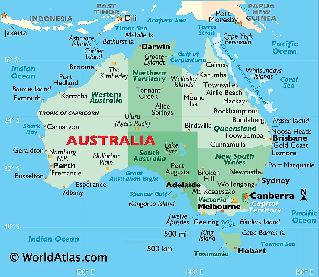
Gibraltar Range National Park in Gibraltar Range on B76
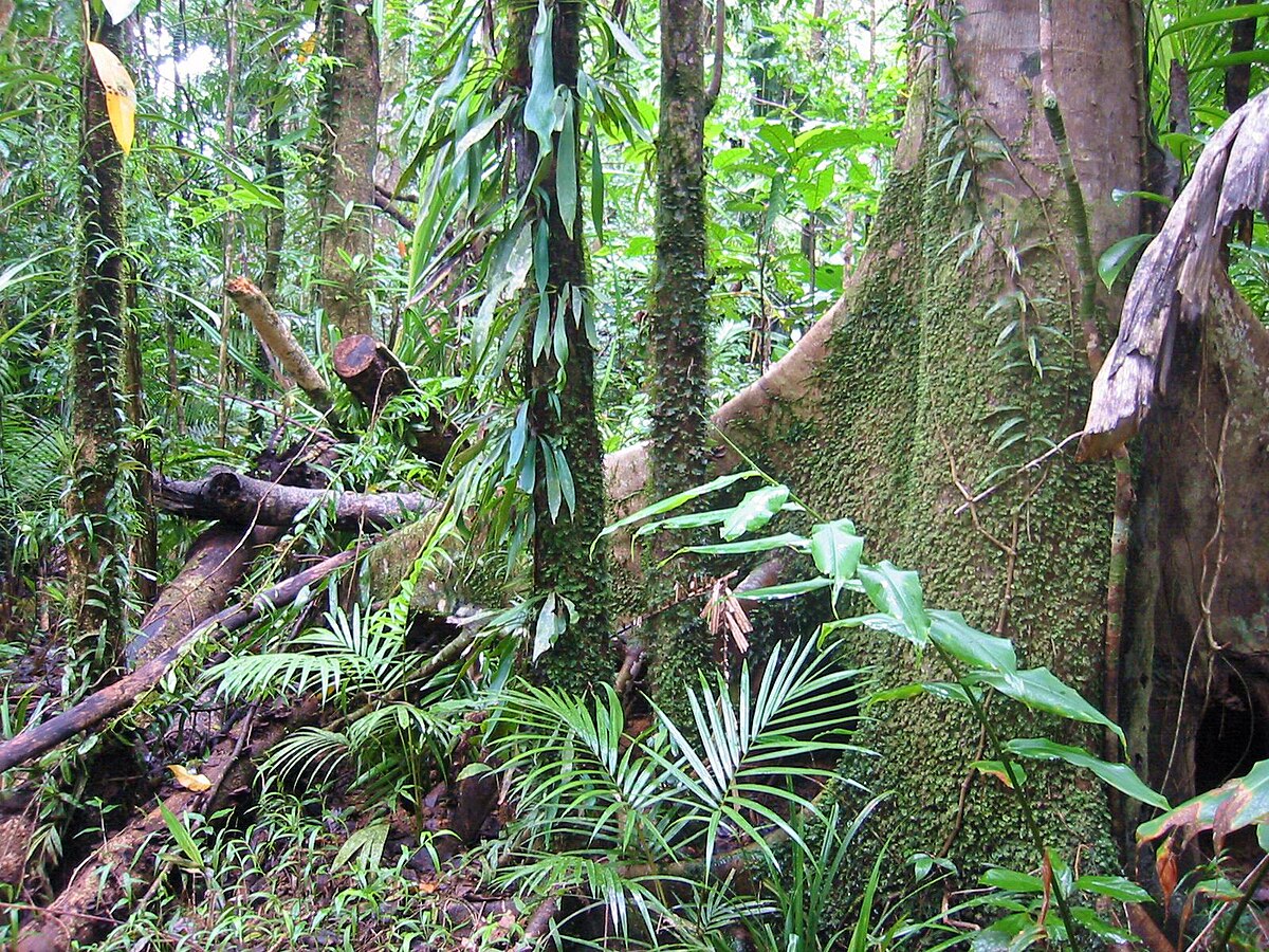
The park is part of the 366-square-kilometre (141 sq mi) Gibraltar Range Important Bird Area (IBA), identified as such by BirdLife International because it is a block of highland forest that supports one of only five remaining populations of the vulnerable rufous scrub-bird, as well as significant populations of green catbirds, Australian logrunners, paradise riflebirds and pale-yellow robins.
Washpool National Park in Washpool on Gwydir Highway
It was established in 1983 to preserve the significant plant and animal populations found in the Washpool and Gibraltar Range forests.
Iluka Nature Reserve in Iluka on Iluka Road
It contains many different plant species ranging from coastal dune species to tropical rainforest species. The Iluka rainforest has a vast range of native animal species ranging from wallabies and kangaroos to wombats and echidnas. Iluka is known for the rare coastal emu.

New South Wales state north [capital = Sydney]

Mount Nothofagus National Park in Woodenbong on Hills Road
The park is part of the Focal Peak Group World Heritage Site Gondwana Rainforests of Australia inscribed in 1986 and added to the Australian National Heritage List in 2007. The park is also part of the Scenic Rim Important Bird Area, identified as such by BirdLife International because of its importance in the conservation of several species of threatened birds.
Border Ranges National Park in Murwillumbah at Gradys Creek
Border Ranges and Lamington National Park are recognised as a biodiversity hotspot, containing a mixture of northern and southern flora species with a number of endemic, rare and endangered species.
Nightcap National Park in Terrania Creek on Tuntable Trail
The park supports a rich diversity of species that includes more than 40 species of mammals, 27 reptiles, 23 frogs, over 140 bird species, over 650 known plant species including numerous ferns and various orchids, as well a diverse variety of fungus and lichens.
Wollumbin National Park in Mount Warning on Mount Warning Road
It surrounds Mount Warning, part of a remnant caldera of a much larger extinct volcano (the Tweed volcano).
Limpinwood Nature Reserve in Limpinwood on Kirbys road
The reserve is composed of virgin old growth sub-tropical rain forest and hardwood species - flooded gum, tallowwood, ironbark and white mahogany.
Numinbah Nature Reserve in Numinbah on route 99
The rare rainforest tree Springbrook leatherwood occurs in this reserve.[9] The subtropical rainforest at the base of the rhyolite cliffs is considered outstanding amongst the rainforests of Australia. Particularly at the heads of Pat Smiths Creek, Crystal Creek and Couchy Creek. Soils are enriched with basalt on a shelf below the Springbrook plateau. Many rare species of plants and unusually tall trees are present beside huge fallen rhyolite blocks. Climbing plants have been recorded at a diameter of one metre.

Norfolk island [capital = Kingston]

Government House in Kingston on Quality Row
It was built in 1829 and, as part of the Kingston and Arthurs Vale Historic Area, is listed on the Australian National Heritage List and as a UNESCO World Heritage site
Old Military Barracks in Kingston on Quality Row
Built during the Second Settlement the complex contains a central soldiers' barrack with officers' quarters on either side. Other buildings around the barracks contained kitchens, washhouses, privies, a military hospital, guard room, powder magazine and a well. Surrounding the complex is a high wall with corner turrets.
New Military Barracks in Kingston on Quality Row
The complex housed 164 soldiers and four sergeants, and contained a soldiers' barracks, officers' quarters, an ammunition magazine, a military hospital - used initially as a ballroom - and various outbuildings.
Convict Hospital in Kingston on Pier Street
This site is important as it portrays the British Empire convict system of the early 1800s. It also portrays the inhumanity and degrading way the convicts were treated – placed in a separate hospital to civilians.

Northern Territories state [capital = Darwin]

Kakadu National Park in Jabiru on Kakadu Highway
Kakadu's rock art provides a window into human civilisation in the days before the last ice age. Detailed paintings reveal insights into hunting and gathering practices, social structure and ritual ceremonies of Indigenous societies from the Pleistocene Epoch until the present. The largest national park in Australia and one of the largest in the world's tropics, Kakadu preserves the greatest variety of ecosystems on the Australian continent including extensive areas of savanna woodlands, open forest, floodplains, mangroves, tidal mudflats, coastal areas and monsoon forests. The park also has a huge diversity of flora and is one of the least impacted areas of the northern part of the Australian continent. Its spectacular scenery includes landscapes of arresting beauty, with escarpments up to 330 metres high extending in a jagged and unbroken line for hundreds of kilometres.
Uluru-Kata Tjuta National Park in Uluru on Lasseter Highway
This park, formerly called Uluru (Ayers Rock - Mount Olga) National Park, features spectacular geological formations that dominate the vast red sandy plain of central Australia. Uluru, an immense monolith, and Kata Tjuta, the rock domes located west of Uluru, form part of the traditional belief system of one of the oldest human societies in the world. The traditional owners of Uluru-Kata Tjuta are the Anangu Aboriginal people.

Queensland state south [capital = Brisbane]

Fossil Site in Riversleigh on Charleville-Bollon Road
The fossils at Riversleigh are rare because they are found in soft freshwater limestone which has not been compressed. This means the animal remains retain their three dimensional shape.
Main Range National Park in Warwick on Cunningham Higway
A mosaic of vegetation types occurs in the park. Rainforests grow in moist or sheltered locations, with open eucalypt forest occurring on the drier ridges and valleys. Montane heath vegetation grows on the cliffs and rocky outcrops.
Mount Barney National Park in Burnett Creek on Waterfall Creek Road
The park has extremely varied vegetation with open forests around the foothills of the peaks, subtropical rainforest above 600m and montane heath shrublands towards the summits. The summit of Mount Ballow is cool temperate rainforest, and on Mount Maroon there are mallee eucalypt shrublands.
Mount Chinghee National Park in Running Creek on road 13
It is part of the Shield Volcano Group of the World Heritage Site Gondwana Rainforests of Australia inscribed in 1986 and added to the Australian National Heritage List in 2007. It is also part of the Scenic Rim Important Bird Area, identified as such by BirdLife International because of its importance in the conservation of several species of threatened birds. It was initially called Telemon Environment Park until it was gazetted as Mount Chinghee National Park in 1994. The national park has no walking tracks or visitor facilities.
Lamington National Park in Binna Burra on Lamington National Park Road
The 20,600 hectares (51,000 acres) Lamington National Park is known for its natural environment, rainforests, birdlife, ancient trees, waterfalls, walking tracks and mountain views.
Springbrook National Park in Springbrook on Old School Rd
Spectacular waterfalls, cascades and tumbling creeks are dominant features in this Gondwana Rainforests of Australia World Heritage Area. The plateau has many lookouts with fabulous views while Mount Cougal offers an insight into the area's logging history.
Great Barrier Reef in Hervey Bay at Point Vernon
The latitudinal and cross-shelf diversity, combined with diversity through the depths of the water column, encompasses a globally unique array of ecological communities, habitats and species. This diversity of species and habitats, and their interconnectivity, make the Great Barrier Reef one of the richest and most complex natural ecosystems on earth.
Fraser Island on Fraser Island at Orchid Beach
The property has exceptional natural beauty with over 250 kilometres of clear sandy beaches with long, uninterrupted sweeps of ocean beach, strikingly coloured sand cliffs, and spectacular blowouts. Inland from the beach are majestic remnants of tall rainforest growing on sandy dunes and half of the world's perched freshwater dune lakes.

Queensland state north [capital = Brisbane]

Paluma Range National Park in Mutarnee on Spiegelhauer Road
Experience the thrill of spotting the rare golden bowerbird, and take a step back in history at Paluma village. Enjoy a rainforest walk and marvel at the breathtaking views from McClellands Lookout.
Edmund Kennedy National Park in Ellerbeck on Clift Road
Edmund Kennedy National Park has a variety of vegetation types and wildlife types, including low-coastal rain forests, eucalyptus forests, white thousand-storey shrub forests, saggy swamps and vast mangrove swamps, and so on. Beech with distinctive red, peeling bark and large yellow flowers can be seen here, as well as Dowers and White Thousand shrubs.
Beach in Mission Beach on Kennedy Esplanade
Much of the area is part of the Coastal Wet Tropics Important Bird Area, identified as such by BirdLife International because of its importance for the conservation of lowland tropical rainforest birds.
Beach Conservation Park in Kurrimine Beach on Stephenson Road
See above.
Beach in Cowley on Cowley Beach Road
See above.
Moresby Range National Park in Coquette Point on Coquette Point Road
See above.
Wooroonooran National Park in Wooroonooran on Josephine Falls Road
Walshs Pyramid provides a challenging hiking trail not far from Cairns, while Goldsborough Valley offers opportunities for canoeing, mountain biking, walking and camping. Josephine Falls features a cascading waterfall and the beginning of the trail up Queensland’s highest peak—Bartle Frere, while Palmerston (Doongan) is renowned for beautiful rainforest, wild rivers, steep gorges, cascading waterfalls and the Mamu Rainforest Canopy Walkway.
Russell River National Park in Bramston Beach on Sassafras Street
The only point of access into the park is from Bramston Beach. Here, the long sandbar, only 30 m across in some areas, supports a fragile environment that changes each year with the tide. Paperbark and mangrove forests line the many creeks and rivers in this tranquil, unspoilt area.
Malbon Thompson Forest Reserve in Aloomba on Dalton Road
Many of the distinct features of the Wet Tropics relate to its extremely high but seasonal rainfall, diverse terrain and steep environmental gradients. In addition to its complex array of species and life forms, the Wet Tropics is also recognised as an area possessing outstanding scenic features, natural beauty and magnificent sweeping landscapes.
Lake Barrine in Barrine on State Road 52
The largest of the natural volcanic lakes in the area, Lake Barrine is 730 m above sea level. It is about 1 km in diameter, with a shoreline of almost 4.5 km, an average depth of 35 m and a maximum depth of 65 m.
Crater Lakes National Park in Lake Eacham on Lakes Drive
A clear, blue lake surrounded by cool rainforest, Lake Eacham offers swimming, birdwatching, canoeing, picnic areas and shady walking tracks.
Curtain Fig National Park in East Barron on Fig Tree Road
This park protects endangered mabi forest and a large fig tree. The formation of this fig tree is unique; its extensive aerial roots drop 15m to the forest floor and form a 'curtain'.
Mount Hypipamee National Park in Malanda on Kennedy Highway
A deep, cylindrical volcanic pipe with a lake at the bottom is an awe inspiring feature of this park. Several different forest types, within a small area, are home to a remarkable diversity of possums.

South Australia state [capital = Adelaide]

Naracoorte Caves National Park in Naracoorte on Limestone Coast
Mammals and other land creatures have fallen into open caves and been unable to escape. The fossil record has been preserved in strata formed from eroded topsoil washed and blown in.

Tasmania island north [capital = Hobart]

Brickendon Estate in Longford at 81 Brickendon Street
Founded in 1824, it consists of a village and manor house, as well as 465ha working farm.
Woolmers Estate in Longford at 658 Woolmers Lane
It consists of an 82ha property, including a two-part manor house, coach house, the National Rose Garden, extensive outbuildings and convict cottages and formal gardens.
Central Plateau Conservation Area in Central Plateau on Highlands Lake Road
The area is one of the largest conservation areas in Australia, covering 15,800 km2, or almost 20% of Tasmania after extensions in 1989 and 2013. It constitutes one of the last expanses of temperate wilderness in the world, and includes the South West Wilderness.
Mole Creek Karst National Park in Mayberry at 330 Mayberry Road
King Solomons cave features an extensive network of sediment, bone deposit, shawls and speleothems which make up stalactites and stalagmites. The Marakoopa cave is popular for its fantastic glow worm display and features two underground streams, large caverns, rim pools, reflections, shawl and flowstone features
Devils Gullet State Reserve in Mersey Forest on Lake MacKenzie Road
It is part of the Tasmanian Wilderness. From the reserve, visitors unable or unwilling to hike the challenging Walls of Jerusalem National Park can catch a glimpse of the stunning landscape.
Walls of Jerusalem National Park in Lake Rowallan on Mersey Forest Road
The park takes its name from the geological features of the park which are thought to resemble the walls of the city of Jerusalem. As a result, many places and features within the park also have Biblical references for names, such as Herods Gate, Lake Salome, Solomons Jewels, Damascus Gate, the Pool of Bethesda. The most prominent feature of the park is King Davids Peak with an elevation of 1,509 metres (4,951 ft) above sea level.
Lake St Clair National Park in Derwent Bridge on Lake St Clair Rd
The Cradle Mountain-Lake St Clair National Park is a significant location of Tasmania's endemic species, 40-55% of the park's documented alpine flora is endemic. Furthermore, 68% of the higher rainforest species recorded in alpine areas in Tasmania are present in the Cradle Mountain-Lake St Clair National Park. The park's alpine vegetation is very diverse and has largely escaped forest fires that have caused neighbouring regions to suffer.
Wild Rivers National Park in Franklin-Gordon on Lyell Hihgway
Much of the Wild Rivers landscape has been shaped by ancient glaciers and is remote and rugged. The area has a much longer natural history, with ancient Huon Pines that grow to an age of over 3000 years. The park supports a diverse range of vegetation, dominated by cool temperate rainforest, drier eucalypt forests and picturesque button grass moorland. The park also contains Aboriginal and convict historic sites.

Tasmania island south [capital = Hobart]

Darlington Probation Station on Maria Island via The Maria Island Ferry, 19 Esplanade W, Triabunna
The most intact example of a convict probation station in Australia presents an array of convict-era buildings.
Coal Mines Historic Site in Saltwater River on Coal Mines Road, C341, Via Premaydena
Coal Mines Historic Site was, for a period of 15 years (1833–48), a convict probation station and the site of Tasmania's (then Van Diemen's Land's) first operational coal mine, "serving as a place of punishment for the 'worst class' of convicts from Port Arthur".
Historic Site in Port Arthur on Arthur Highway
Ruins include the huge penitentiary and the remaining shell of the Convict Church, which was built by inmates. Solitary confinement cells in the Separate Prison building were used to inflict mental punishment in place of floggings.
Cascades Female Factory in South Hobart at 16 Degraves Street
The Cascades Female Factory was purpose-built in 1828 and operated as a convict facility until 1856. It was intended to remove women convicts from the negative influences and temptations of Hobart, and also to protect society from what was seen as their immorality and corrupting influence. The Factory was located, however, in an area of damp swamp land, and with overcrowding, poor sanitation and inadequate food and clothes, there was a high rate of disease and mortality among its inmates. The Cascades Female Factory is the only remaining female factory with extant remains which give a sense of what female factories were like.
Hartz Mountains National Park in Raminea on C632
The backbone of rock in the park is dolerite, while the southern areas at lower altitudes are constituted from sedimentary rocks formed from sediments deposited by marine, glacial and freshwater sources between 355 and 180 million years ago. The relief has been modified over time by several ice ages, forming cirques, horn peaks, aretes and glacial troughs.
Mount Field National Park in Uxbridge at 66 Lake Dobson Road
Across its base, waterfalls pour through cool-temperate rainforest, while high above are dramatic peaks dotted with glacial lakes and classically Tasmanian alpine plants such as pandani, scoparia, pineapple grass and cushion plants.
Southwest National Park in Red Knoll Lookout on C607
While much of the park is remote and hard to reach, it offers spectacular scenery that can be easily accessed on four wheels. There are many other ways to enjoy this park, from scenic drives, picnics and short walks to breathtaking flights, multi-day wilderness treks and kayak adventures.

Victoria state [capital = Melbourne]

Royal Exhibition Building and Carlton Gardens in Melbourne at 9 Nicholson Street, Carlton
The site comprises three parcels of Crown Land in the City of Melbourne, being two Crown Land Reserves for Public Recreation (Carlton Gardens) and one dedicated to the exhibition building and the recently-constructed museum (Exhibition Reserve).
Budj Bim Cultural Landscape in MacArthur on Mt Eccles Rd
Located within the Country of the Gunditjmara, an Aboriginal nation in the southwest of Australia, the property includes the Budj Bim Volcano and Tae Rak (Lake Condah), as well as the Kurtonitj component, characterized by wetland swamps, and Tyrendarra in the south, an area of rocky ridges and large marshes. The Budj Bim lava flows, which connect these three components, have enabled the Gunditjmara to develop one of the largest and oldest aquaculture networks in the world. Composed of channels, dams and weirs, they are used to contain floodwaters and create basins to trap, store and harvest the kooyang eel (Anguilla australis), which has provided the population with an economic and social base for six millennia.

Western Australia state [capital = Perth]

Prison in Fremantle at The Terrace
Initially known as the Convict Establishment (or just The Establishment), Fremantle Prison was constructed between 1851 and 1859, using convict labour. It was initially used for convicts transported from Britain, but was transferred to the colonial government in 1886 for use for locally-sentenced prisoners.
Shark Bay in Denham on 353
One of the superlative natural phenomena present in this property is its stromatolites, which represent the oldest form of life on Earth and are comparable to living fossils. Shark Bay is also one of the few marine areas in the world dominated by carbonates not associated with reef-building corals. This has led to the development of the Wooramel Seagrass Bank within Shark Bay, one of the largest seagrass meadows in the world with the most seagrass species recorded from one area. These values are supplemented by marine fauna such as dugong, dolphins, sharks, rays, turtles and fish, which occur in great numbers. The hydrologic structure of Shark Bay, altered by the formation of the Faure Sill and a high evaporation, has produced a basin where marine waters are hypersaline (almost twice that of seawater) and contributed to extensive beaches consisting entirely of shells. The profusion of peninsulas, islands and bays create a diversity of landscapes and exceptional coastal scenery.
Ningaloo Coast in Exmouth on Murat Road
The most dominant marine habitat is the Ningaloo reef, which sustains both tropical and temperate marine fauna and flora, including marine reptiles and mammals. The main terrestrial feature of the Ningaloo Coast is the extensive karst system and network of underground caves and water courses of the Cape Range. The karst system includes hundreds of separate features such as caves, dolines and subterranean water bodies and supports a rich diversity of highly specialized subterranean species. Above ground, the Cape Range Peninsula belongs to an arid ecoregion recognized for its high levels of species richness and endemism, particularly for birds and reptiles.
National Park in Purnululu on Highway 1
It includes the Bungle Bungle Range, a spectacularly incised landscape of sculptured rocks which contains superlative examples of beehive-shaped karst sandstone rising 250 metres above the surrounding semi-arid savannah grasslands.