click highlighted hovered text for more info, see
Peru
UNESCO
world heritage sites
Ancash region center
[capital = Huaraz]
Chankillo Archaeoastronomical Complex
in
El Castillo
on
Carretera a Chankillo
The site includes a triple-walled hilltop complex, known as the Fortified Temple, two building complexes called Observatory and Administrative Centre, a line of 13 cuboidal towers stretching along the ridge of a hill, and the Cerro Mucho Malo that complements the Thirteen Towers as a natural marker. The ceremonial centre was probably dedicated to a solar cult, and the presence of an observation point on either side of the north-south line of the Thirteen Towers allows the observation both of the solar rising and setting points throughout the whole year.
Archaeological Site
in
Chavin de Huantar
@
This former place of worship is one of the earliest and best-known pre-Columbian sites. Its appearance is striking, with the complex of terraces and squares, surrounded by structures of dressed stone, and the mainly zoomorphic ornamentation.
Andean Road
at
S9 32 54 W76 59 10 + S9 30 52 W77 1 14 + S9 29 15 W77 2 8 + S9 27 55 W77 4 17 + S9 26 4 W77 5 51 + S9 16 8 W77 9 37
The Qhapac Nan, Andean Road System includes 273 component sites spread over more than 6,000 km that were selected to highlight the social, political, architectural and engineering achievements of the network, along with its associated infrastructure for trade, accommodation and storage, as well as sites of religious significance.
Ancash region north
[capital = Huaraz]
Huascaran National Park
in
Marcara
@
Situated in the Cordillera Blanca, the world's highest tropical mountain range, Mount Huascaran rises to 6,768 m above sea-level. The deep ravines watered by numerous torrents, the glacial lakes and the variety of the vegetation make it a site of spectacular beauty. It is the home of such species as the spectacled bear and the Andean condor.
Andean Road
at
S9 4 10 W77 14 41 + S8 50 44 W77 22 49 + S8 45 59 W77 27 3 + S8 19 48 W77 49 10
See Andean Road above.
Apurimac region
[capital = Abancay]
Andean Road
at
S14 22 53 W71 29 2 + S13 44 45 W72 53 36
See above.
Arequipa region
[capital = Arequipa]
Historical Centre
of
Arequipa
see
detail
The historic centre of Arequipa, built in volcanic sillar rock, represents an integration of European and native building techniques and characteristics, expressed in the admirable work of colonial masters and Criollo and Indian masons. This combination of influences is illustrated by the city's robust walls, archways and vaults, courtyards and open spaces, and the intricate Baroque decoration of its fassades.
Cuzco region north
[capital = Cuzco]
Andean Road
at
S13 7 33 W72 5 36 + S13 2 38 W72 2 31 + S13 12 27 W72 53 47 + S13 9 42 W72 54 34 + S12 43 8 W72 1 44 + S12 57 17 W71 59 1 + S13 1 6 W72 2 1
See Andean Road above.
Historic Sanctuary
of
Machu Picchu
@
Machu Picchu stands 2,430 m above sea-level, in the middle of a tropical mountain forest, in an extraordinarily beautiful setting. It was probably the most amazing urban creation of the Inca Empire at its height; its giant walls, terraces and ramps seem as if they have been cut naturally in the continuous rock escarpments. The natural setting, on the eastern slopes of the Andes, encompasses the upper Amazon basin with its rich diversity of flora and fauna.
Manu National Park
in
Challabamba
@
This huge 1.5 million-ha park has successive tiers of vegetation rising from 150 to 4,200 m above sea-level. The tropical forest in the lower tiers is home to an unrivalled variety of animal and plant species.
Cuzco region south
[capital = Cuzco]
City
of
Cusco
see
detail
Situated in the Peruvian Andes, Cuzco developed, under the Inca ruler Pachacutec, into a complex urban centre with distinct religious and administrative functions. It was surrounded by clearly delineated areas for agricultural, artisan and industrial production. When the Spaniards conquered it in the 16th century, they preserved the basic structure but built Baroque churches and palaces over the ruins of the Inca city.
Andean Road
at
Inquiltambo + Qapaq Nam + S13 37 48 W71 41 55 + S13 57 10 W71 29 57 + S14 10 31 W71 21 57
See Andean Road above.
Huanuco region
[capital = Huanuco]
Andean Road
at
S9 38 10 W76 57 52 + S9 40 57 W76 51 14 + S9 46 44 W76 53 24 + S9 53 8 W76 48 29 + S9 51 29 W76 51 5
See Andean Road above.
Ica region
[capital = Ica]
Lines and Geoglyphs
from
Palpa to Nasca
@
These lines, which were scratched on the surface of the ground between 500 B.C. and A.D. 500, are among archaeology's greatest enigmas because of their quantity, nature, size and continuity. The geoglyphs depict living creatures, stylized plants and imaginary beings, as well as geometric figures several kilometres long. They are believed to have had ritual astronomical functions.
La Libertad region
[capital = Trujillo]
Chan Chan Archaeological Zone
in
Huanchaco
@
The monumental zone of around six square kilometres in the centre of the once twenty square kilometre city, comprises nine large rectangular complexes (‘citadels’ or ‘palaces’) delineated by high thick earthen walls. Within these units, buildings including temples, dwellings, storehouses are arranged around open spaces, together with reservoirs, and funeral platforms. The earthen walls of the buildings were often decorated with friezes representing abstract motifs, and anthropomorphical and zoomorphical subjects. Around these nine complexes were thirty two semi monumental compounds and four production sectors for activities such as weaving wood and metal working.
Andean Road
at
S7 56 15 W78 0 44
See Andean Road above.
Lima region north
[capital = Lima]
Sacred City
of
Caral
It dates back to the Late Archaic Period of the Central Andes and is the oldest centre of civilization in the Americas. Exceptionally well-preserved, the site is impressive in terms of its design and the complexity of its architectural, especially its monumental stone and earthen platform mounts and sunken circular courts. One of 18 urban settlements situated in the same area, Caral features complex and monumental architecture, including six large pyramidal structures. A quipu (the knot system used in Andean civilizations to record information) found on the site testifies to the development and complexity of Caral society. The city’s plan and some of its components, including pyramidal structures and residence of the elite, show clear evidence of ceremonial functions, signifying a powerful religious ideology.
Historic Centre
of
Lima
see
detail
Although severely damaged by earthquakes, this 'City of the Kings' was, until the middle of the 18th century, the capital and most important city of the Spanish dominions in South America. Many of its buildings, such as the Convent of San Francisco (the largest of its type in this part of the world), are the result of collaboration between local craftspeople and others from the Old World.
Andean Road
at
S12 4 29 W76 0 37 + S12 3 11 W75 58 21
See Andean Road above.
Lima region south
[capital = Lima]
Andean Road
at
S12 15 01 W76 53 46 + S12 4 50 W76 46 28 + S12 5 1 W76 45 56 + S12 2 19 W76 43 15 + S12 2 11 W76 42 11 + S12 1 30 W76 40 25 + S12 1 34 W76 39 49 + S12 4 34 W76 31 7 + S12 8 23 W76 13 25
See above.
Piura region
[capital = Piura]
Andean Road
at
S4 42 17 W79 34 27
See above.
Puno region
[capital = Puno]
Andean Road
at
S16 25 55 W69 8 60 + S16 18 13 W69 16 20 + S16 15 57 W69 18 25 + S16 12 17 W69 25 3 + S15 52 54 W69 57 25 + S15 52 23 W70 0 59 + S15 46 46 W70 3 15 + S15 9 49 W70 17 17 + S14 41 15 W70 45 24
See above.
San Martin region
[capital = Moyobamba]
Rio Abiseo National Park
in
Parcoy
There is a high level of endemism among the fauna and flora found in the park. The yellow-tailed woolly monkey, previously thought extinct, is found only in this area. Research undertaken since 1985 has already uncovered 36 previously unknown archaeological sites at altitudes of between 2,500 and 4,000 m, which give a good picture of pre-Inca society.
 click highlighted hovered text for more info, see
  click highlighted hovered text for more info, see
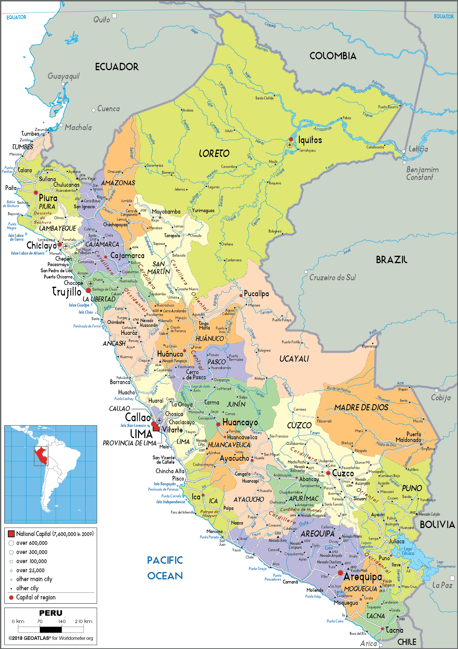