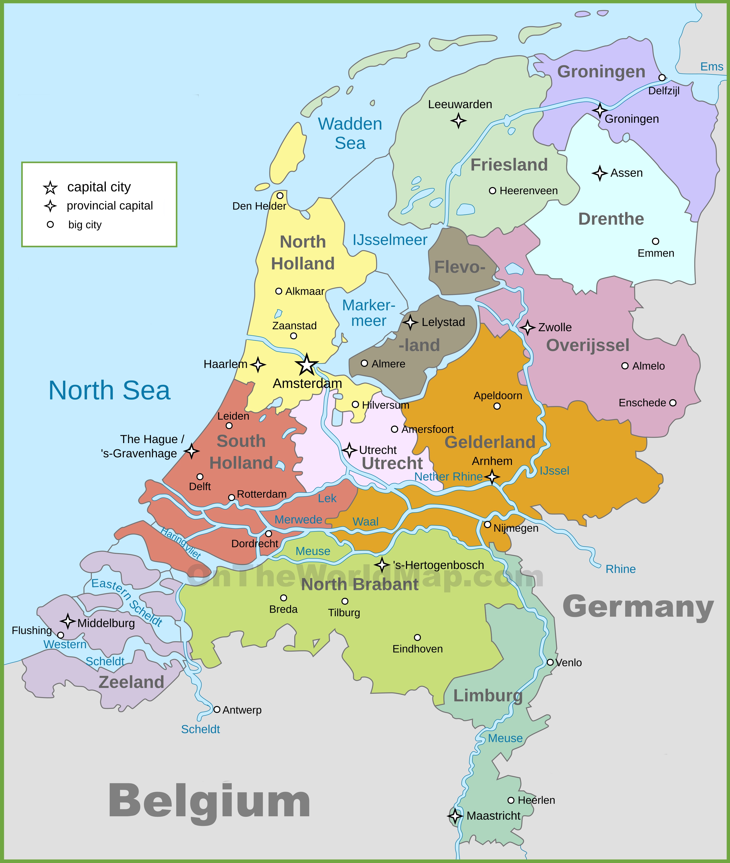
#Netherlands # UNESCO #world heritage sites
#Curassao Island (Caribbean) [capital = Willemstad]
#Historic Area
in
#Willemstad
#
Punda, the oldest part of the city, was built in the 17th century on the eastern side of Sint Anna Bay, adjacent to Fort Amsterdam and is the only part of the city that had a defence system consisting of walls and ramparts. The other three historic urban districts (Pietermaai, Otrobanda and Scharloo) date from the 18th century. Water Fort and Rif Fort, also included in the inscribed property, were built in the late 1820s as part of a more extensive series of fortifications.
#Drente province [capital = Assen]
#Colony of Benevolence
in
#Veenhuizen
at
#Oude Gracht 22
#
The museum tells both the story of 400 years of criminal punishment in the Netherlands and the intertwined story of Veenhuizen from Colony Village to Prison Village.
#Colony of Benevolence
in
#Wilhelminaoord
at
#
Kon. Wilhelminalaan 53
#
Wilhelminaoord was one of the farming colonies established by the Society of Benevolence in 1821 to decrease poverty by providing sustainable employment for able-bodied poor people.
#Flevoland province [capital = Lelystad]
#Surroundings
in
#Schokland
#
Schokland was a peninsula that by the 15th century had become an island. Occupied and then abandoned as the sea encroached, it had to be evacuated in 1859. But following the draining of the Zuider Zee, it has, since the 1940s, formed part of the land reclaimed from the sea. Schokland has vestiges of human habitation going back to prehistoric times.
#Friesland province [capital = Leeuwarden]
#Wadden Sea
in
#Hollum
#
It is considered one of the most important areas for migratory birds in the world, and is connected to a network of other key sites for migratory birds. Its importance is not only in the context of the East Atlantic Flyway but also in the critical role it plays in the conservation of African-Eurasian migratory waterbirds. In the Wadden Sea up to 6.1 million birds can be present at the same time, and an average of 10-12 million pass through it each year.
#Eisinga Planetarium
in
#Franeker
at
#Eise Eisingastraat 5
#
Powered by one single pendulum clock, it provides a realistic image of the positions of the Sun, the Moon, the Earth and five other planets (Mercury, Venus, Mars, Jupiter and Saturn). The planets revolve around the Sun in real time and the distance between the planets are at scale. The model fills the entire ceiling of the room, making it one of the earliest predecessors of the ceiling and projection planetariums of the 20th and 21st centuries.
#D.F. Wouda Steam Pumping Station
in
#Lemmer
at
#
Gemaalweg 1a
#
The pumping station is a steam-driven installation to prevent flooding of the low-lying areas of Friesland.
#Gelderland province [capital = Arnhem]
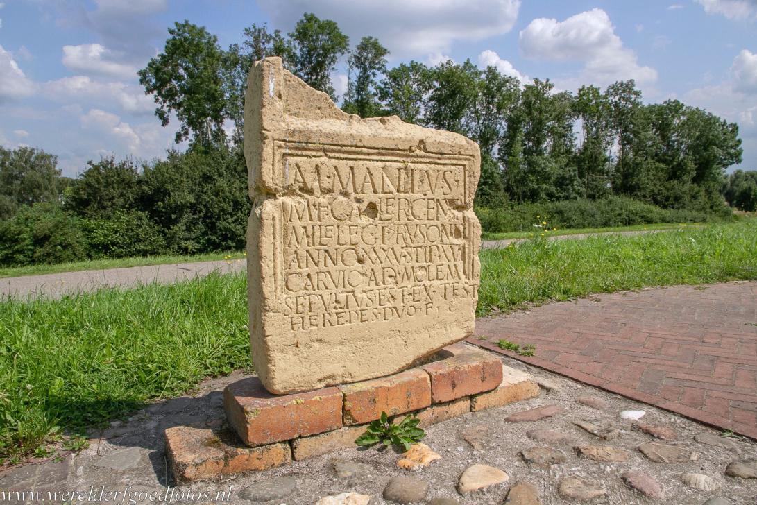
#Carvium Roman Fortress
in
#Herwen
at
#
Boswaaisestraat 2A
#
Stray finds suggest that the military settlement was occupied between the second quarter of the first century and the fourth century.
#Ancient Roman Fortress
in
#Arnhem
at
#
Meginhardweg 55
#
The fort served to protect Roman river traffic and may have been situated near one of the Drusus canals, artificial waterways dug northward from the Rhine to facilitate military movements.
#Roman Temple
in
#Elst
at
#
Grote Molenstraat 2
#
The site was already recognized as a holy place in the Iron age, before the Romans settled the Batavians in this area. In those days, the first century BCE, it was an open air sanctuary. A first temple may have been built over here at the end of the first half of the first century CE.
#Valkhof Park
in
#Nijmegen
at
#
Kelfkensbos 59
#
The word Nijmegen is derived from Noviomagus, the name of a Roman city that existed in the second and third centuries. Like many urban centers in Antiquity, it was in fact a set of settlements, some of which existed at the same time.
#Roman aqueduct
in
#Berg en Dal
on
Oude Kleefsebaan + Kerstendalseweg + Uilenputweg + Meerwijkselaan + Theresiaweg + Sophiaweg + Broerdijk + Hengstdalseweg + Berg en Dalseweg
#
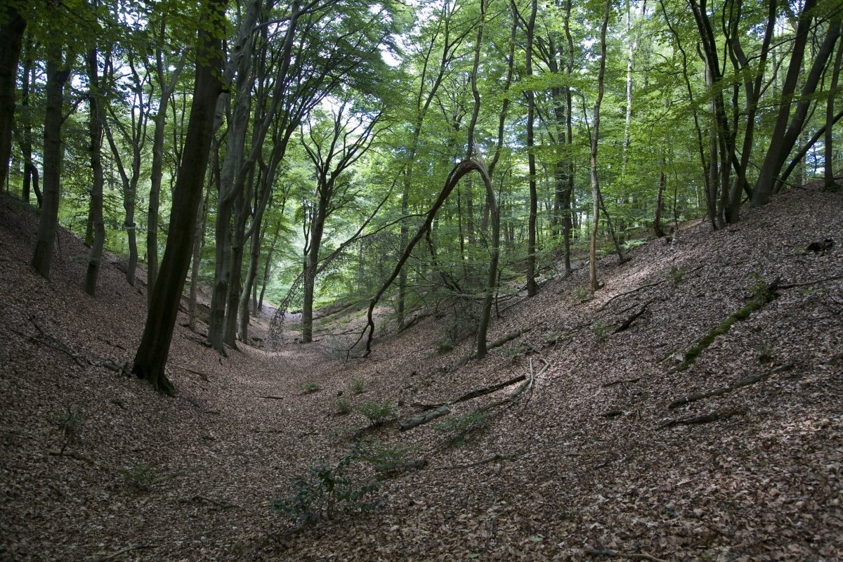
This water conduit was a wooden channel, running through three man-made valleys (Kerstendal, Louisedal and Mariënbosch), among other places, and across three dams (Swartendijk, Cortendijk and Broerdijk). The wooden channel hasn’t survived, but the dams and valleys are still tucked away in the landscape, like an impressive heritage of Roman engineering skills.
#North Holland province [capital = Amsterdam]
#Canal Ring Area
in
#Amsterdam
#
It comprises a network of canals to the west and south of the historic old town and the medieval port that encircled the old town and was accompanied by the repositioning inland of the city’s fortified boundaries, the Singelgracht. This was a long-term programme that involved extending the city by draining the swampland, using a system of canals in concentric arcs and filling in the intermediate spaces.
#Defence Line
of
#Amsterdam
at
#N +
#NW +
#SW +
#SE
#
Extending 135 km around the city of Amsterdam, this defence line (built between 1883 and 1920) is the only example of a fortification based on the principle of controlling the waters. Since the 16th century, the people of the Netherlands have used their expert knowledge of hydraulic engineering for defence purposes. The centre of the country was protected by a network of 45 armed forts, acting in concert with temporary flooding from polders and an intricate system of canals and locks.
#Beemster Polder
in
#Beemster
#
The Beemster Polder, dating from the early 17th century, is is an exceptional example of reclaimed land in the Netherlands. It has preserved intact its well-ordered landscape of fields, roads, canals, dykes and settlements, laid out in accordance with classical and Renaissance planning principles.
#South Holland province [capital = The Hague]
#Roman Fort
in
#Valkenburg
on
#
Castellumplein
#
Some of the finds can be seen in the Torenmuseum in Valkenburg. On the central square of town, the Castellumplein, the contours of the fort are visualised with bronze dots in the pavement. The foundations of one of the fort's gates have been reconstructed as well.
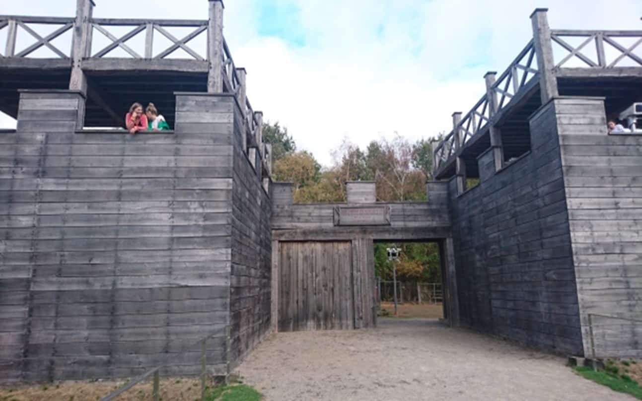
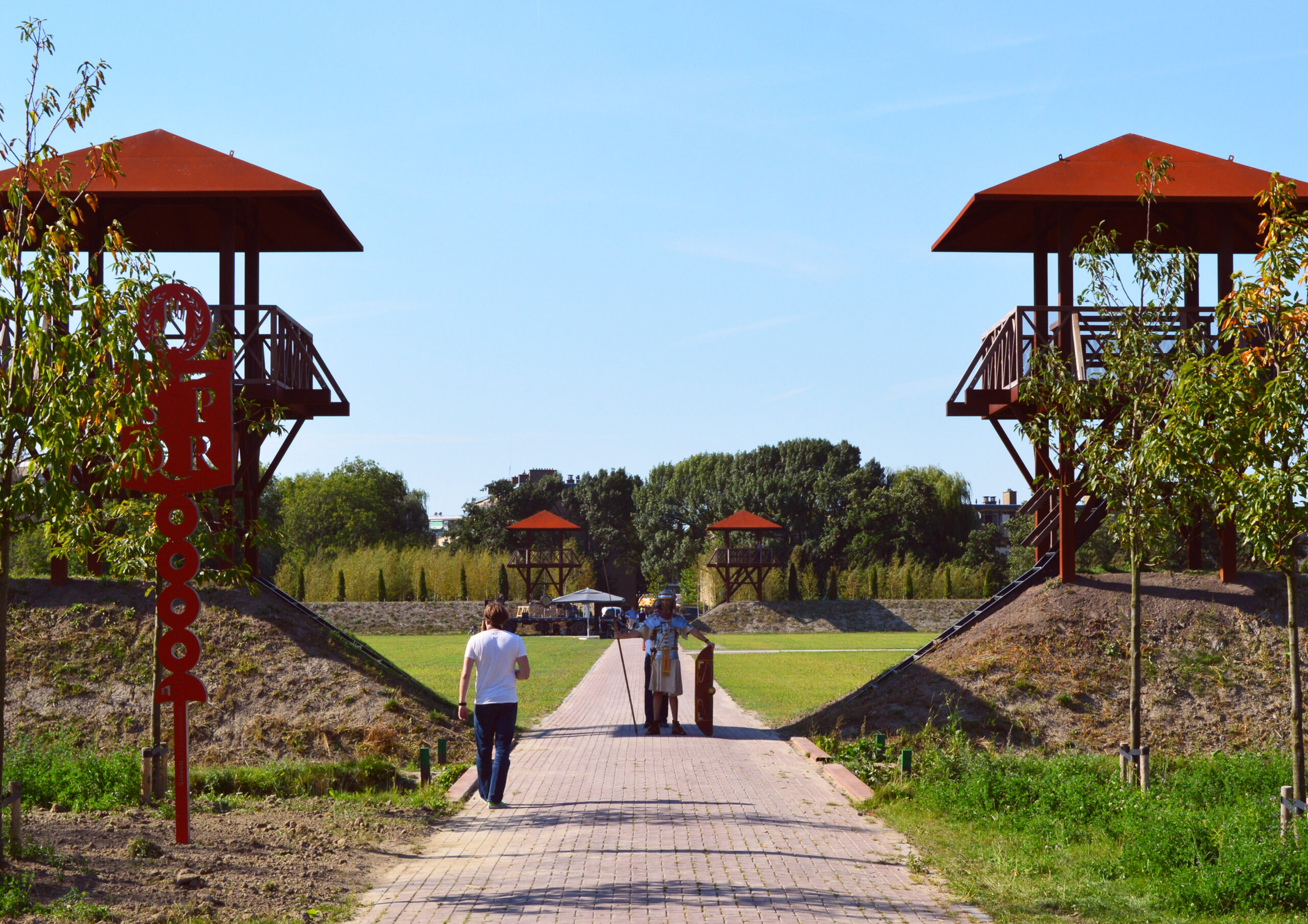
#Archeological Park Matilo
in
#Leiden
on
#
Besjeslaan
#
About 2000 years ago, where Roman Archaeological Park Matilo is located, stood a Roman border fortress: Castellum Matilo. This fort was on the border (Limes) of the Roman Empire. Feel Roman for a moment in Park Matilo where the high earth walls, watchtowers and special "line images" show you the history of the area.
#Arentsburgh
in
#Voorburg
at
#
Pr. Mariannelaan 103
#
Remains of the Roman town have been excavated in park Arentsburg in modern Voorburg. It seems that the ancient settlement was, in spite of its small size (about a thousand inhabitants), a regular city with the common Roman gridiron lay-out and normal buildings like a bathhouse.
#Corbulo canal
from
#Voorschoten
till
Leidschendam
#
The canal connected the mouths of the rivers Meuse and Rhine in the currently Dutch delta area. Parts of the canal remained in use up to about 275 AD when the area became depopulated due to Frankish attacks.
#Van Nellefabriek
in
#Rotterdam
at
#Van Nelleweg 1
#
The site is one of the icons of 20th-century industrial architecture, comprising a complex of factories, with façades consisting essentially of steel and glass, making large-scale use of the curtain wall principle. It was conceived as an ‘ideal factory’, open to the outside world, whose interior working spaces evolved according to need, and in which daylight was used to provide pleasant working conditions.
#Mill Network
in
#Kinderdijk-Elshout
#
The outstanding contribution made by the people of the Netherlands to the technology of handling water is admirably demonstrated by the installations in the Kinderdijk-Elshout area. Construction of hydraulic works for the drainage of land for agriculture and settlement began in the Middle Ages and have continued uninterruptedly to the present day. The site illustrates all the typical features associated with this technology – dykes, reservoirs, pumping stations, administrative buildings and a series of beautifully preserved windmills.
#Utrecht province [capital = Utrecht]
#Roman 'Turris' at Fort Vechten
in
#Bunnik
at
#
Marsdijk 2
#
The Romans, who apparently chose the spot because it controlled a side-arm of the Lower Rhine, built their castellum by the year 4 AD, and possibly named it after that river, Fectio. This fort was quite important from time to time as a supply-base for the invasion of Germany. It attracted the local population as well, which came to settle in the vicus at either end of the fort.
#Rietveld Schroeder House
in
#Utrecht
at
#Prins Hendriklaan 50
#
Part of the quality of the house is the flexibility of its spatial arrangement, which allows gradual changes over time in accordance with changes in functions. At the same time the building has also many artistic merits, and its visual image has strongly influenced building design in the second half of the 20th century. The interiors and furniture are an integral part of its design and should be given due recognition.
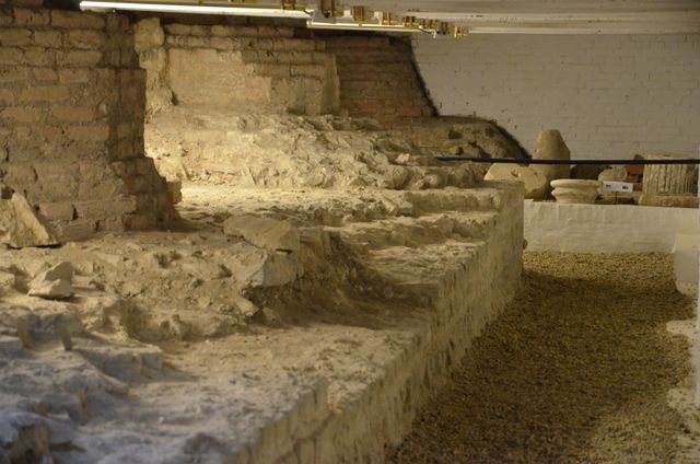
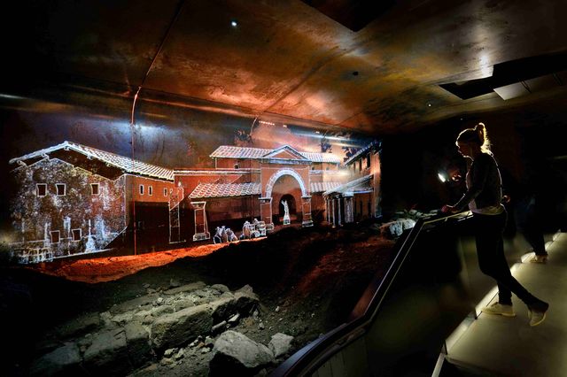
#Castellum of Traiectum
in
#Utrecht
at
#Domplein 4
#
Discover 2000 years of Utrecht history underneath the Dom square. Explore the archaeological finds, that date back up to the Roman Castellum ‘Trajectum’, with an interactive flashlight. Walking through the huge pillar foundations of the medieval Gothic Dom Cathedral, history literally springs to life.
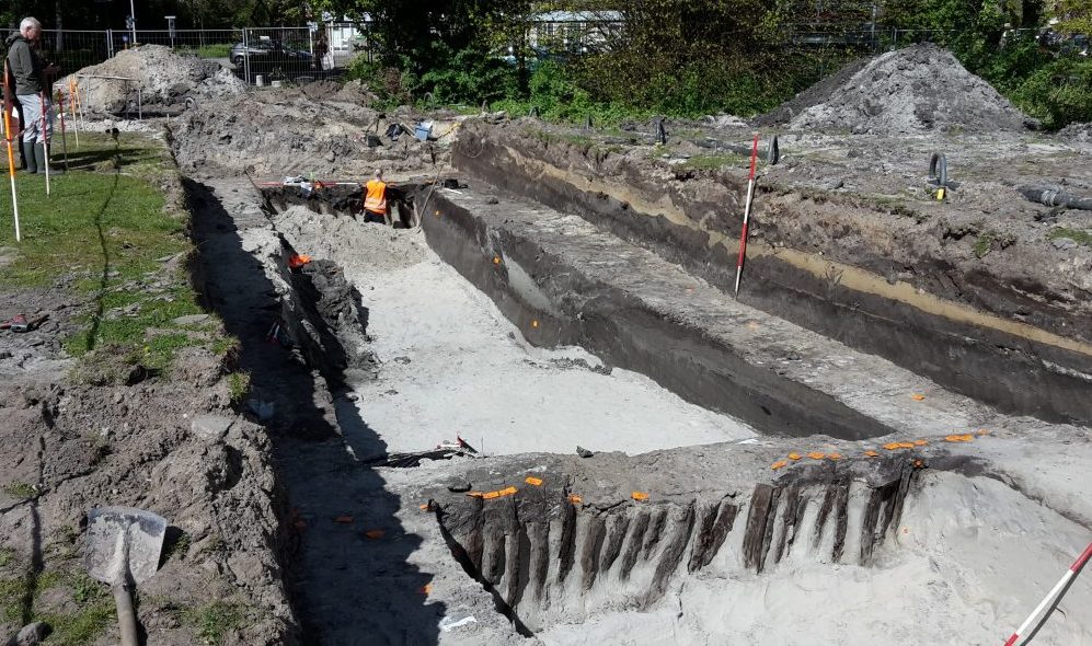
#Roman castellum
in
#Woerden
at
#Hoge Woerdplein 1
#
During construction work on a new underground parking facility in the city center of Woerden, the remains of numerous old Roman buildings and a Roman cargo ship were found.