click highlighted hovered text for more info, see
Chile
UNESCO
world heritage sites
Antofagasta region
[capital = Antofagasta]
Andean Road
at
S23 38 51.25 W68 3 25.96 + S23 35 31.73 W68 2 14.35 + S23 32 49.42 W68 1 20.46 + S23 28 22.96 W68 0 5.43 + S23 26 20.86 W67 59 36.49 + S23 25 0 W67 59 24.56 + S22 50 12.32 W68 13 30 + S22 9 4.37 W68 18 10.82 + S22 13 22.83 W68 16 53.6 + S22 15 13.50 W68 37 56.18 + S22 12 45.17 W68 37 45.88 + S22 11 1.64 W68 37 47.91 + S22 8 39.21 W68 37 50.10 + S22 6 8.16 W68 37 40.06
It demonstrates mastery in engineering technology used to resolved myriad problems posed by the Andes variable landscape by means of variable road construction technologies, bridges, stairs, ditches and cobblestone pavings.
Arica region
[capital = Arica]
Andean Road
near
Putre
at
S18 21 25.01 W69 37 13.62 + S18 19 26.18 W69 35 33.22 + S18 17 24.28 W69 35 42.71 + S18 15 0 W69 34 60
See above.
Chinchorro Culture
in
Arica
at
Faldeo Norte del Morro de Arica + Colon 10
Chinchorro mummies, the oldest in the world, are common in this area, in large part because the arid soil of the Atacama Desert is rich in nitrate salts, which both dry and preserve organic materials.
Chinchorro Culture
in
Camarones
at
Caleta Camarones, route A-376
In 2010, a monumental sculpture celebrating the Chinchorro Culture was inaugurated in the town as part of the bicentennial of the Chilean Republic. The sculpture is four and a half meters tall and weighs eight tons; it is located in the vicinity of the archaeological sites 'Camarones 14 and 15'.
Atacama region
[capital = Copiapo]
Andean Road
at
S26 18 42.54 W69 35 51.91 + S26 21 26.33 W69 36 11.43 + S26 22 34.17 W69 36 13.76 + S26 22 37.99 W69 37 26.37 + S26 23 15.98 W69 38 47.65 + S26 24 5.51 W69 39 35.97 + S26 25 39.89 W69 40 59.55 + S26 26 52.7 W69 41 58.29 + S26 28 35.7 W69 43 25 + S26 30 5.4 W69 44 39.81 + S26 31 36.71 W69 45 56.11 + S26 33 12.33 W69 47 16.13 + S26 34 51.57 W69 48 35.51 + S26 36 28.67 W69 50 0.26 + S26 38 2.69 W69 51 1.12
See above.
Los Lagos region
[capital = Puerto Montt]
Churches
in
Chiloe Islands
see
detail
The abilities of the people of Chiloe as builders achieved its highest expression in these wooden churches, where farmers, fishermen and sailors exhibited great expertise in the handling of the most abundant material in this environment, wood. Along with the churches, the mestizo culture resulting from Jesuit missionary activities has survived to the present day.
O'Higgins region
[capital = Rancagua]
Sewell Mining Town
in
Machali
at
S34 5 4 W70 22 58
The most outstanding attributes of the property are the industrial installations, which take advantage of the hillside incline for the mineral grinding process; the buildings that combine houses on the upper floors with business or services in the ground floor; the service buildings, public spaces and pedestrian circulation system; the electric infrastructure and drinking water and sewer systems; the assorted and diverse networks of pipes crossing the town, as well as the Rebolledo Bridge; and the urban design and the ensemble's location in the stark Andean landscape. Among the industrial installations, the Concentrator (still in working order) and the energy infrastructure stand out, as well as the Punta de Rieles (Rails' End) sector at the highest point on the property.
Tarapaca region
[capital = Iquique]
Humberstone Saltpeter Works
in
Santa Laura
at
Kilometro 47, Ruta a-16
The Humberstone site contains the attributes that express the quality of urban settlements, such as the living quarters, public spaces and the regular grid pattern of the Camp, with a main square around which communal buildings are clustered. Other relevant attributes are the remains of the railway line that linked Santa Laura and Humberstone, the gravel heaps, the construction techniques, architectural styles and materials, in particular the costron and the Pampa concrete, distinctive construction materials together with the calamine and timber that were brought from other latitudes.
Valparaiso region [capital = Valparaiso]
main land
Historic Quarter
of
Valparaiso
see
detail
It is composed of five interlaced neighbourhoods: La Matriz Church and Santo Domingo Square, located between the hills and the plain and comprised of the church and late 19th-century buildings typical of the seaport architecture; Echaurren Square and Serrano Street, predominantly commercial in character and marked by the presence of the Port Market, commercial establishments and active street trade; Prat Pier and Sotomayor and Justicia squares, comprising the main transversal axis of the area and containing the largest public spaces; the Prat Street and Turri Square area around the foothill, featuring a number of examples of monumental architecture; and the two hills of Cerro Alegre and Cerro Concepcion, a single neighbourhood planned and developed to a large extent by German and English immigrants, with squares, viewing points, promenades, alleyways, stairways and the top stations of some of Valparaiso's distinctive funicular elevators.
Valparaiso region [capital = Valparaiso]
island
Rapa Nui National Park
on
Easter Island
@
Prominent among the archaeological pieces are the moai that range in height from 2 m to 20 m and are for the most part carved from the yellow-brown lava tuff, using simple picks (toki) made from hard basalt and then lowered down the slopes into previously dug holes. There are many kinds of them and of different sizes: those in the process of being carved, those in the process of being moved to their final destinations -the ahu-, those being torn down and erected. The quarries (Rano Raraku and others) are invaluable evidence of the process of their carving. The ahu vary considerably in size and form; the most colossal is the Ahu Tongariki, with its 15 moai. There are certain constant features, notably a raised rectangular platform of large worked stones filled with rubble, a ramp often paved with rounded beach pebbles, and levelled area in front of the platform. Also extremely valuable are the rock art sites (pictographs and petroglyphs), which include a large variety of styles, techniques and motifs. Other archaeological sites are the caves, which also contain rock art. There is also a village of ceremonial nature named Orongo which stands out because of its location and architecture. While it has not attracted as much attention, the housing and productive structures are of extreme interest.
 click highlighted hovered text for more info, see
  click highlighted hovered text for more info, see
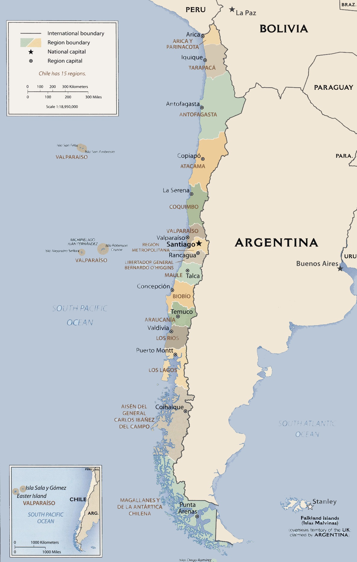